Geology
To many, the Canadian Shield is the quintessential Canadian landscape – the rugged North, and a land of forests and lakes. But many haven’t realized that a portion of the Shield extends southward though Ontario, and into the U.S. The Frontenac Arch, as this hourglass-shaped outlier of the Canadian Shield is known as The Bones of the Mother in Mohawk (Kanien’kehæa:ka) tradition.
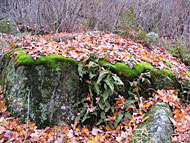
Even to the most casual observer, the Frontenac Arch is an entirely different landscape than the remainder of southern Ontario and upper New York State. To someone driving across the land, an otherwise flat and plain countryside is suddenly interrupted by rolling hills and rugged cliffs, topped with windswept pines, and valleyed with sinewy creeks and tranquil lakes and wetlands. But about a billion years ago, this was a far more dramatic landscape. The Frontenac Arch, and the Canadian Shield, was a massive range of towering mountains. It took hundreds of millions of years for these mountains to weather down to their roots – and those basement rocks of the mountains are what we experience in this landscape today.
The lowest elevation along the Frontenac Arch lies at the east end of Lake Ontario. Through the last ice ages, glaciers scoured the basins for the Great Lakes and as each of the lakes filled, they overflowed on their race to the sea. A young Lake Ontario first flowed out the Oswego River. As the land rose further, released from the glacial ice, the lake tipped gently towards the east. The lake’s waters rose up the flanks of the Frontenac Arch to spill between the granite hilltops, becoming the “Thousand Islands” in this flooded landscape.
At the end of the last ice age, the intersection of the Frontenac Arch and the St. Lawrence River Valley was formed. The Arch connects the Canadian Shield and the boreal forest to the forests of the Adirondack and Appalachian Mountains – a south to north/north to south migration route. The river valley is a route from the Great Lakes forest heartland of the continent to the forests of the Atlantic Coast. The Thousand Islands are at the very centre of that intersection. Here, the five great forest regions of the eastern continent meet and intermingle, with many species at range limits, and with many as remnant populations from forests altered by millennia of climate change and evolving landscapes. This region has, arguably, Canada’s greatest diversity of plant and animal communities.
You can learn more about the geology features of the Frontenac Arch through the geoscience data available at the Ontario Ministry of Northern Development and Mines. The geoscience data is that of the Ontario Geological Survey (OGS) and can be viewed on Google Earth. Visit: http://www.mndm.gov.on.ca/en/mines-and-minerals/applications/ogsearth.
The Creation of the Frontenac Arch
The Frontenac Arch is made up of older rock from the Neo- to Mesoproterozoic Era (the event of the Rodinia supercontinent). The surrounding areas to the East and West of the Frontenac Arch are much younger rocks from the Paleozoic Era.
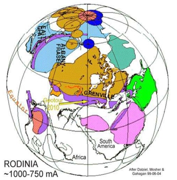
The geological story of the Frontenac Arch region begins at the formation of the supercontinent Rodinia about 1100 million years ago. It was only up until two billion years ago did the core of North America, Laurentia, take form (brown core on figure below). The ancient continent of Laurentia at the time was positioned fairly close to the equator and would eventually become the core of the North American continent. Between about 1.3 billion years and 1 billion years ago, a second large continental mass moved northwesterly against Laurentia. As a result of the collision, the ancient (1.8 to 2.5 billion years) Precambrian rocks that formed the edge of Laurentia were pushed lower into the crust, deformed by heat and pressure, and then thrust up to form the northeasterly-trending Laurentian Mountain Belt. The roots of this former mountain belt, known geologically as the Grenville Province, extend from the coast of Labrador, through Quebec, Ontario and northern New York and then disappear beneath younger rocks of central U.S.A. A northwesterly-trending relic of this belt that connects the Grenville rocks of the Algonquin Highlands (Ontario) with similar rocks of the Adirondack Highlands (New York State) is known as the Frontenac Arch.
Precambrian Rock Profile of the Frontenac Arch
The Frontenac Arch was once a rugged mountain belt (the Laurentian Mountain Belt) that had been eroded to a relatively uniform Precambrian plain with a maximum relief generally less than 100 meters. Beginning about 500 million years ago, the Cambrian and Ordovician sedimentary rocks (sandstone, limestone, shale) that form the cover over the Precambrian rocks were deposited in shallow seas that flooded the region. Whether these rocks originally covered the Arch itself and were later stripped away by erosion and ice or whether the Arch was a positive feature at that time (i.e. stood above water level) and did not receive sediments is an open question, although the evidence seems to favour the latter.

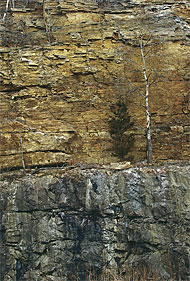
The rocks forming the Frontenac Arch, called the Grenville Series or Grenville Supergroup, are exposed along a southwest-trending belt that stretches from the present day coast of Labrador through Quebec and Ontario and then disappears under younger rocks of central U.S.A. They are a complex of metamorphic rocks that include various gneisses (e.g. granitic gneiss, quartz-biotite-feldspar gneiss), migmatites (layered gneisses that have been invaded by narrow granitic bands parallel to the layering), quartzite and crystalline limestone. The part of the Grenville Supergroup that underlies the Thousand Island region is called the Central Metasedimentary Belt or CMB. As the name suggests, it is a belt of metamorphosed sediments representing a series of crustal fragments (now “Terranes” or Domains”) thrust to the northwest as the belt grew over time.
The older Grenville rocks (granite, granite gneiss, schist, quartzite, marble) were relatively resistant to erosion and commonly form prominent knolls and humps where the original cover of younger sediments was either stripped away or never deposited. The present day St. Lawrence River, flowing over these Precambrian knobs and knolls (modified locally by glacial ice scouring and polishing), has given rise to the topography of the Thousand Islands.
The Ice Age – Pleistocene (Late Quaternary) Glaciation
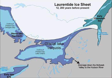
About 20,000 years ago, much of eastern Canada and northeast U.S.A. was covered by the great Laurentide Ice Sheet (several kilometers thick). The eastern part of the ice sheet, known as the Labrador lobe, flowed southerly from its center in Ungava. In the Frontenac Arch region, ice moved southwesterly, roughly parallel to the geological “grain” of the Grenville rocks. Between about 17,000 and 14,000 years BP (before present) the ice began to melt back to the north. By about 12,500 years BP a large glacial lake called Lake Iroquois had formed to the west of the Arch, forerunner of the smaller Lake Ontario. A few hundred years later, the ice had melted back to allow seawater of the Champlain Sea to flood most of the area of the present Gulf of St. Lawrence, the Ottawa and St. Lawrence river valleys and Lake Champlain. During this period, marine clays and silts of the Champlain Sea were deposited on top of earlier glacial sediments. As the sea retreated, these deposits (glacial sediments and marine clays) were reworked by wave action in shallow waters, resulting in a mixture of deposits. By about 9,000 years BP the Champlain Sea had disappeared and by about 6,000 years BP, the present Great Lakes and Ottawa and St. Lawrence river drainage patterns had been established.
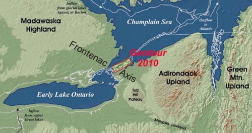
The above figure reflects the landscape about 9,000 years ago – near the end of the last ice age. The arm of the Atlantic Ocean reached into the Frontenac Arch from the melting of the continental ice sheet before the significant rebounding of the crust that had been depressed beneath the glacial ice for thousands of years.
Reference: “Geology Tours” by Allan Donaldson & Chris Findlay. “Geotour of Frontenac Arch Biosphere Reserve” (2008). “Geology Boat Tour of the St Lawrence”, Thousand Islands 2010 booklet.
Soils of the Frontenac Arch
The composition of the soil profile of the Frontenac Arch Biosphere Region is not surprisingly, greatly reflective of the Arch’s unique geological rock type.
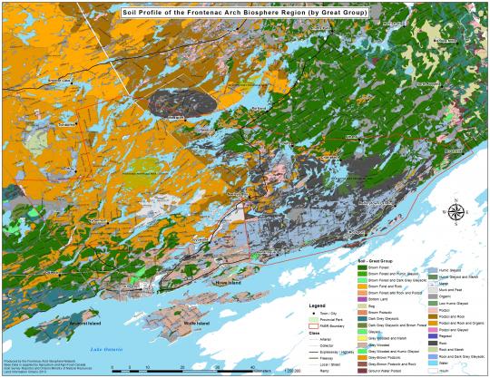
The supplied data is from the Soil Survey Reports on the Agriculture and Agri-Food Canada website. For further details and original soil maps visit: http://sis.agr.gc.ca/cansis/publications/surveys/on/index.html
Flora
The Frontenac Arch Biosphere has a tremendous variety of plant life. The diversity of flora, like the fauna of the region, is owed to several key factors. The region is at the intersection of major continental migration routes, it has a complex geology and rugged landform, and climate effects play a major role.
The Biosphere is at a crossroads of migration routes. The north-south route is the Frontenac Arch itself – a bridge of Canadian Shield from the Algonquin and Laurentian highlands to the Adirondack Mountains. This rugged granite landform is the worn-down roots, the very basement rocks, of a billion year-old mountain chain. This land-bridge provides a common ground between the forests of Appalachia and the boreal.
The east-west route is the St. Lawrence Valley, which is the route from the Great Lakes heartland of the continent to the Atlantic coast.
Long-term migrations of plants are far more subtle than the season to season migrations of birds with which we are more familiar. The ranges of plants are sternly linked to climate conditions over time. However, the conditions of soils, topography and dispersal mechanisms play a large part. The north-south, and east-west routes that intersect here have enriched our Biosphere’s natural world. The routes have provided the means and conditions for five forest regions of eastern North American to intermingle here. These are the Great Lakes – St. Lawrence forest, the boreal, the Appalachian, the Atlantic Coastal Forest and the Carolinian Forest. There are also species of the tall-grass prairie to be found.
Plants are often quite specialized in needs for nutrition, shelter, temperature ranges among other factors. It happens that this region abounds in niche opportunities.
The rugged landscape means that there are literally millions of slopes and valleys, oriented to all points of the compass. As a result, there are hot, sunny, sheltered, cool, windswept, step, gentle, rocky, cliff-faced, gravel, moist, dry – and all other character of slopes one can think of. Valleys are equally complex, where they may be lake or wetland filled, level plains of post-glacial lake-bottom clays, dry ravines, bogs, fens, sand or gravel beds.
The terrain interplays with the complexities of the region’s climate and weather patterns. The Frontenac Arch is the landform that confines Lake Ontario to its basin, and the lake becomes a great moderator of the climate from season to season, lessening the seasonal extremes and prolonging the swing of each season. The vast volume of the lake is slower than land to cool in the fall, and retards the warming of the land in spring. While we expect that the growing season would be shorter as one moves north, the moderating lake allows a longer growing season at the upper end of the St. Lawrence Valley than one sees moving eastward down the valley, for some hundreds of kilometres. Coupled with the effect of slopes facing to or from the sun, climate plays a large part in the conditions which modify the so-called normal ranges of plants, and animals.
An example of the cumulative effects of migration routes, geology and climate here is that wire birch and red spruce of the Atlantic forests reach this far west. Several species of the Carolinian can be seen little further northward. Among these are pignut hickory, buttonbush and summer grape. From the boreal forests are sweet gale, barren-grounds strawberry and balsam fir. Pitch pine, the tree of the east coast pine barrens, and hobble-bush of Appalachia, are common here, but elsewhere very rare in Canada.
Fauna
The Frontenac Arch Biosphere has an astonishing wealth of animal life. As with the terrific diversity of the flora of the region, the Biosphere’s variety of animals owes to several key factors. These are the fact that the region is at the intersection of major continental migration routes, the region has a complex geology and rugged landform, and climate effects. This area also has an Important Bird Area designation from Bird Studies Canada.
Long-term migrations are far more subtle than the season to season migrations of birds with which we are more familiar. Mammals – with the exception of bats – most insects, reptiles and amphibians move about in search of food, mates or opportunity, and their rangings may bring them new new parts of what they may see as familiar landscapes. However, the north-south and east-west routes that intersect here have enriched our Biosphere’s natural world.
Fauna is often quite specialized in needs for food, shelter, temperature ranges among other factors. There are many generalists, such as crows, coyotes and raccoons, but animals such as salamanders, songbirds and more specifically, insects have more particular requirements. It happens that this region abounds in habitat types and niche opportunities.
An example of the cumulative effects of migration routes, geology and climate here is the eastern rat snake. At one time, its range covered a large area of eastern North America. Now, there are limited places where this large and gentle snake is found, exhibiting isolated remnants of the former range, all others with the exception of the Biosphere, being southerly. One of the last population areas is the Frontenac Arch Biosphere, where the climate, rocky dens for winter refuge and food sources continue to provide suitable conditions.
Other examples are that the region hosts both southern and northern flying squirrels, where the southern species favours deciduous forests, and the northern cousin resides in mixed coniferous woodlands. From time to time, opossums cross northward through the islands of the Arch to make local appearances. This region hosts both cottontail rabbits, a southerner; and snowshoe hares.
There are many “species at risk” in the region, totaling 34 for both plants and animals. Species at risk are any naturally occurring, native species that are in danger of extinction or disappearing from geographic areas. Sometimes called the “endangered species list”, these plants and animals fall into various levels of endangerment, from species of concern to extinct. A large number of such species in our area is due to the fact that there are actually refuge favourable conditions, lesser risk factors and available habitats to support species that may have been eliminated from other parts of their normal range. With conservation efforts based on studies and modelling programs, the Biosphere region may continue to host species that are otherwise more seriously threatened in surrounding areas.
For more information, visit:
- Queen’s University Biological Station: https://qubs.ca/resources/species-lists
- Species at Risk in Ontario: https://www.ontario.ca/page/species-risk-ontario
- Species at Risk in Canada: https://www.canada.ca/en/environment-climate-change/services/species-risk-public-registry.html
- Frontenac Bird Studies: http://frontenacbirds.ca/
- The Kingston Field Naturalists: http://kingstonfieldnaturalists.org/
- Thousand Islands National Park: http://www.pc.gc.ca/pn-np/on/lawren/natcul.aspx

